
BACKGROUND OF THE PROJECT
THE PROJECT SITE
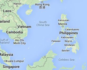
The target location is a Philippine island town classified as a third class municipality in the Philippine Province of Western Samar – also simply referred to as Samar Province. (More data about the project site, the project site and Samar Province are shown in a brief profile of the project host community. The project site belongs to the Eastern Visayas (Region VIII) Administrative Region and is one of twenty-four towns and cities in the Province of Samar.
GEOGRAPHY AND DEMOGRAPHY
SOCIO-ECONOMIC PROFILE OF THE PROJECT SITE
Geography. The project site in Samar Province is located at the coordinates: 11°38′ North 124° 47′ East. The town has a Total Land Area of 140.26 Square Kilometers (km2) or the equivalent of 54.15 Square Miles (sq mi).
The size of the project site is 0.8953 % of the Total Land Area of Western Samar Province (6,048.03 km²). In turn, Western Samar consists 47.07 % – nearly one-half of the size – of the entire Samar Island 12,849 km2 (4,961 sq mi)].
Out of the twenty four (24) constituent cities and towns of Samar Province, the project site is clustered along with the eleven other Western Samar Cities and Municipalities of Almagro, Basey, Calbiga, Catbalogan, Gandara, Santa Rita, Santo Niño, Tarangnan, Villareal, Wright, Zumarraga, Pinabacdao, Talalora, Hinabangan, Jiabong, Motiong, Marabut, Daram, San Sebastian, San Jose de Buan, Matuguinao to constitute the second Congressional district of Samar Province.

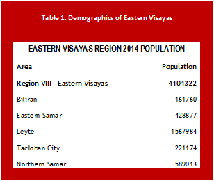
Demography. The project site comprises of fifty-eight (58) Barangays or Villages. As per the 2010 Census Survey, the project site has a Total Population of 41,322. The town has a Density ratio of 290/km2 (760/sq mi) showing it to be minimally populated in proportion to its land area. In reference to the 2010 census the population of the Project site is projected to be 65,020 in 2014 at the local population growth rate in the Province of 1.12% per year.
The total past and projected population figures of the project site exclude those that succumb to internal or out-of-country migration – a pattern that has been going on ever since the 1950s and even earlier. In 2010, the total population of Western Samar was 733,777. The total projected population of the Western Samar by the end of 2014 is 1,154,612.
In 2007, the size of the project site’s population compared to that of Western Samar is 5.5%. In 2010, the ratio was 5.6% and may still be projected to be the same for 2014, barring any factors that would radically alter demographics figures in the project site town and the Western Samar Province. The correspondence zip code of the project site is 6722 and its local phone Dialing prefix code is 55.
Inland areas of the site is mostly unpopulated. Of the current demographic, at least 99% percent live along the coasts of the island town.
The current local government of the project site chief executive, is Mayor Lucia Latorre Astorga who replaced her spouse Benito Astorga after the latter passed away following his re-election to office.
Economy. The major aquaculture products from the seas around the project site are seaweed, Galunggong, Alumahan, Tamban, Pompano, Bisugo (bream), Lapu-lapu, Rabbitfish, Slipmouth and assorted mussels, oysters, crabs and shells. Kelp seaweed is a major commodity of the project site and the product is exported worldwide.
The project site agriculture generates income mostly from coconut (the prime commodity of the island town and the entire Eastern Visayas), banana, corn and other crops such as sweet potato, cassava and legumes.
Aquaculture, poultry and swine products can be produced in the province. Marine products abound in the entire province. In the project site and other parts of the province, chicken and egg supply is still bought come from Cebu.
Economic Ranking. Particularly in the Marcos administration, Eastern Visayas was classified as first-ranked Philippine most depressed region – in a near tie in rankings with the Bicol Region – having the highest incidence of Kwashiorkor – a severe form of malnutrition, among many other signs of poverty.
The project site on its own may have maintained lower incidences of such evidence of ultra-poverty but it did not lag far behind the rest of Eastern Visayas during that period and up to some extent today.
Investments Track Record. The public sector and private enterprise invested in the following enterprise for livelihood purposes for the benefit of the citizens of the project site:
Other livelihood such as kelp seaweed production appear to be doing well as the site is one of the most prolific supplier of kelp seaweed in the country.


The Fish Cage livelihood program centered upon a cottage industry framework. It was initiated by the immediate past Mayor of the project site, the late Benito Astorga. It is however in need of augmentation and support today in terms of technology, financial resources as well as marketing. Support for agriculture and small cottage industries need a boost and there is a need to engage in more sustainable farming, enterprise and light-to-heavy industrial activity to elevate the status of the project site from its current category as third class.
Patterns of the project site’s Depopulation. The project site, like many other localities of Eastern Visayas, used to occupy the lead in the most populated towns and cities of the Philippines. Because of so many factors, the population has been decimated. At the present time, the site’s population is spread thinly over too many areas in the Philippines and around the globe and the remaining families in the project site are a fraction of the site’s people that joined the diaspora.
Comparative Demographics. All the past and present trends of the project site’s depopulation are the reasons why the site has a hypothetical 2014 population of 65,020. Whereas, a Metro Manila locality like Malabon City with 19.76 square kilometers land area, equivalent to only 14.08% of the land area of the site but it has a projected population size of 496,413 by 2013 – equivalent to 7.62 times more than the number of people in the site.
Valenzuela City with a land area of 47.02 km2 has a population of 605,379 as of 2013. The entire Valenzuela City population resides in a city that is one-third the size of the site but its population is ten times bigger.
Both Malabon City and Valenzuela City have large Visayan population components – some of them coming from the project site in Samar and from other nearby Samar towns and cities. Navotas City that was merely separated from the original Malabon City that has a total land area of 10.77 km2 that is 13 times smaller than that of the project site, has a projected 2013 population of 350,011 or 5.38 times larger than the project site’s.
A substantial part of the population of both Malabon City and Navotas City are engaged in fishing. Many of those that work in the fishery industry are from Samar and other parts of Eastern Visayas. Whole enclaves and communities in Malabon and Navotas speak the same specific language (Waray-Waray) that is spoken in the project site and other Eastern Visayas localities.
Eastern Visayas Migration Problems
. . .Leyte, for a very long time, has always been considered as the number three biggest voters’ source in the entire country
For some time in the distant past, Leyte was the biggest vote source in Philippine elections until it slid down to second and then third. At this time, Leyte and Samar combined shared a place in the top seven to eight largest populated provinces and regions in the country.
However, the record increase in the populations of Calabarzon (most populated region, 2014 demographics data), the National Capital Region (second most populated region), Central Luzon (third most populated region) and even other Visayas Regions including those of Mindanao, is indubitably connected to internal migration from Samar and Leyte to these areas.
DOTC Expansion of Services of Catbalogan City Airport
September 2, 2014 GCPH Corporation
INFRASTRUCTURE. CULTURAL DEVELOPMENT
Infrastructure. The project site offers limited urban amenities. The basic rural infrastructure exists to include water-borne transport, bountiful potable water supply available to the general public, power supply provided by the Samar Electric Cooperative (SAMELCO) II, mobile cellular phone transmission towers, cable television, minimum sports and recreational facilities as well as the most basic service establishments.
Entrepreneurs in the project site have yet to build decent-sized billeting facilities for tourists while there are a substantial number of spots and sights in the town that are worth visiting for both local and foreign guests.
The project site is not landlocked to the main Samar Island therefore obviously for its public land transport there is a visible constraint to engage heavily in travel over land.
With the only access to the main island of Samar being the sea, Maritime Transport is more predominant in the entire island of the project site as it is with many other island towns of Samar and the Philippines as a whole.
To initialize new business, expanded commercial and industrial activity in the area, will spur more employment, increase the size of formerly idle land converted into profit creation centers, invite more investments into the project site and improve the lives of the people.
Such activity will most logically give impetus to public sector to improve infrastructure, set off greater building activity in the town as well as in nearby communities. The rush of development helps to expand the service sector and the resulting job and wealth creation rises exponentially.
Education.
Primary and secondary level education in the site is relatively adequate. However, for the tertiary level, facilities are limited with most of the residents taking up both secondary and higher education in Catbalogan, Tacloban, and Southern Leyte and as far as Cebu and Metro Manila.
For its primary education, the site has 58 primary schools with a total enrollment of 10,397 students. The number of secondary learning institutions is nearly the same in number but with only around half of the total enrollment for primary levels.
Due to their high demand, many Filipinos take up both technical and general education courses in the maritime discipline – thereafter being engaged by operators and servicing companies in the maritime industry all around the world.
Preferential hiring and treatment of Filipino crew has always been the practice in international maritime companies, among many other types of business organizations all over the globe.
RATIONALE FOR THE PROJECT

Investments, Education as Pump Primers for the Growth of the project site. As a third class municipality, the site has a relatively low priority for investors. The Third and Fourth World problem of lack of Access and Mobility plague the project site. The presence of infrastructure is bound to resolve this lack and will contribute to reducing the public sector’s high costs of undertaking development.
Given that the palpable decrease in Eastern Visayas demographic can be attributed to the severe lack of development in the area, the situation can be expected to change with the introduction of economic development initiatives.
Combining more than 500,000 hectares (has.) of idle public land in Eastern Visayas out of a total area of 2,156,290 has., approximately 1,400,000 to 1,500,000 has. of underutilized privately owned land in the region awaits to be developed. Multiple thousands of hectares of aquamarine ecosystems that still have to be exploited to produce commodities that fetch high revenues both in the local and international market.
Out of these at the very least parcels of land amounting to 1,000,000 hectares are best suited for conversion from agricultural land to commercial farming, aquaculture farming, industrial zones, among many other livelihood ventures. This makes up for a high of 1,500,000 hectares of land that is not properly used and that does not generate income.
In highly progressive cities and provinces, land of this size could be the source of income reaching trillions of currency. In the case of the site, out of the total of 14,026 hectares, conservatively estimating more than half or around 9,000 hectares of land is either entirely unproductive or else, underutilized. Read more from here
